What we offer
Wastewater and effluent monitoring
Independent, satellite-based monitoring of sewage treatment plants, industrial discharge points, and receiving waterbodies — detecting anomalies that on-site sensors routinely miss or misreport.
Service overview
India’s sewage treatment plants are required to meet CPCB discharge standards, but compliance monitoring relies on on-site sensors and manual sampling that are costly to operate at scale and vulnerable to manipulation. Published reports document persistent sensor tampering and unauthorised bypass discharge at STPs across major cities.
Regulators and scheme administrators cannot trust the data they receive — and cannot afford the inspection frequency needed to verify it independently.
Anora Intel provides satellite-based monitoring of STP discharge behaviour and receiving waterbody conditions — an independent, tamper-proof verification layer that operates continuously, scales across hundreds of plants simultaneously, and cannot be bypassed by the entity being monitored.
Service modules
STP compliance monitoring
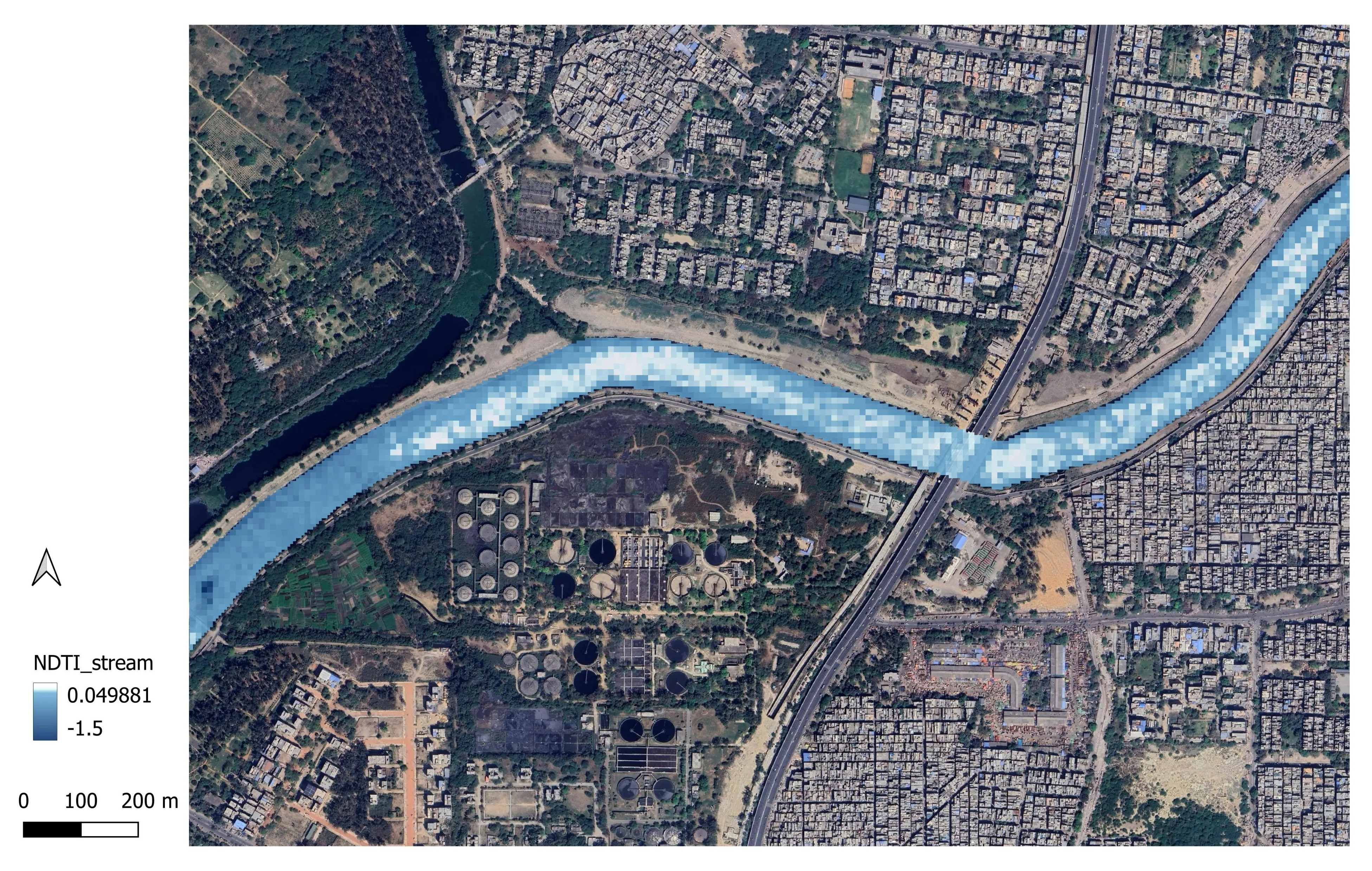
Regulatory compliance reportingContinuous satellite-based monitoring of sewage treatment plant discharge behaviour. Detects plumes, spectral anomalies — NDTI, turbidity, chlorophyll-a — and thermal signatures indicating untreated effluent. Operates during daylight (optical) and night-time (thermal). SAR cloud-penetrating monitoring under active development.
Inspection prioritisation
Directing enforcement capacityEach STP is assigned a compliance score and inspection priority ranking based on detected anomaly frequency, severity, and predicted risk windows. Directs limited inspection capacity to the highest-risk sites at the most effective moments.
Receiving waterbody quality monitoring
Cross-boundary pollution trackingContinuous monitoring of rivers, canals, and lakes downstream of discharge points. Tracks water quality indicators over time, enabling trend analysis, cross-boundary pollution tracking, and inter-state water quality reporting.
Industrial effluent and supply chain due diligence
ESG evidence for investorsSatellite-based verification of industrial discharge compliance for supply chain actors, financial institutions, and investors. Independent, tamper-proof ESG evidence layer.
How we work
The detection methodology is built on a machine learning model trained on hundreds of historical satellite images for each monitored site. Every pixel value and spectral index from that image history is used as a training input. The model is then applied to new images as they arrive, flagging anomalous discharge plumes at 90% confidence.
Monitoring runs on a four-day cadence using open-source satellite data, with additional passes from commercial satellites at random intervals the monitored entity cannot predict. Daylight monitoring uses optical imagery; night-time monitoring uses thermal data.
The satellite layer is a screening tool, not standalone regulatory evidence. Water sampling is required to confirm flagged anomalies as discharge events. The service works alongside existing on-site systems — providing the independent verification layer those systems cannot provide for themselves.
Applications
Independent STP verification
Regulators receive an evidence layer that does not depend on operator-reported sensor data — and that the operator cannot tamper with or bypass. The satellite sees the receiving waterbody, not the instruments inside the plant.
Scalable enforcement
The same monitoring system that covers one plant covers a hundred. City-wide or state-wide STP oversight becomes operationally feasible at a fraction of the cost of equivalent ground inspection frequency.
Enforcement prioritisation
Inspection priority scores direct limited enforcement capacity to the highest-risk sites when anomalies have been detected — making inspections more likely to find non-compliance and harder for operators to anticipate.
Scheme reporting and certification
Monitoring outputs provide supporting evidence for Swachh Bharat Mission ODF+ and ODF++ certification, Namami Gange programme reporting, and NMCG compliance documentation.
Deterrent effect
Operators who know their discharge behaviour is monitored continuously and independently face a higher cost of non-compliance. The monitoring itself reduces bypass and tampering.
Typical outputs
Outputs are structured to the needs of the engagement — from a one-time baseline assessment through to a recurring compliance dashboard with automated anomaly flagging.
- Compliance dashboard — interactive view of STP discharge behaviour, anomaly history, and compliance scores across a monitored network
- Inspection priority list — ranked list of STPs by detected anomaly frequency and severity, updated each monitoring cycle
- Receiving waterbody reports — time-series summaries of water quality indicators at key downstream monitoring points
- Anomaly alerts — notifications when new discharge events are detected, with satellite evidence attached
- Scheme-aligned documentation — structured reports meeting the evidence requirements of Swachh Bharat Mission, Namami Gange / NMCG, and CPCB / SPCB reporting frameworks
This service supports compliance under Swachh Bharat Mission, Namami Gange, Jal Jeevan Mission, and CPCB frameworks. See our scheme alignment →
Engagement model
Engagements typically begin with a scoped pilot covering a defined set of STPs and a specific receiving waterbody — enough to validate the methodology in the local context and produce a first deliverable before committing to full operational deployment.
A pilot covering 20 STPs can deliver a first compliance dashboard within two months of kick-off. From there, coverage scales to city or state level without a proportional increase in cost or time.
Monitoring cadence, output format, and integration with existing inspection workflows are defined at the scoping stage and refined as the engagement develops.
Ready to talk about your context?
If your question fits this service or sits alongside it, we can help shape a clear scope and practical outputs.
Get in touch →